The Tides of Boston Harbor
The water along the Charlestown Navy Yard rises and falls by an average of 9 feet with every tide, but can often rise much more due to storms, hurricanes and the phase of the moon! The water levels during high and low tides in Boston Harbor are also changing over time, but how can we measure the relative rise of sea level in Boston Harbor?
The National Oceanic and Atmospheric Administration (NOAA) has kept daily records of Boston’s tides since 1921. That is nearly 100 years of data showing the changes over time, but scientists were hoping to go even further back.
Now, early records created right in front of today’s USS Constitution Museum and in the Navy Yard are allowing researchers to reach back another century to the 1820s.
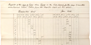
In 1826 Loammi Baldwin Jr. measured the tides at the Navy Yard in order to determine the proper height for one of the first naval dry docks in the United States. His measurements determined how dry dock #1 would be built. Recently, researchers Stefan Talke from Penn State University, Andrew Kemp from Tufts University and Jon Woodruff from UMass Amherst looked back at Baldwin’s original notes along with other Navy records to determine the exact height of tides in 1826, extending our record of Boston Harbor sea levels to nearly 200 years.
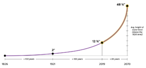
The pace of relative sea level rise in Boston Harbor continues to speed up. At this rapidly accelerating pace, sea level could rise an additional 36 inches in the next 50 years if global greenhouse gas emissions are not greatly reduced!*
* Data from Climate Ready Boston
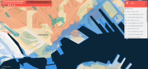
How will your neighborhood fair?
The City of Boston continues to lead the way in urban discussions of mitigating climate change. The City has a great resource for more information along with an interactive map:
https://www.boston.gov/departments/environment/preparing-climate-change